Wednesday, April 26, 2006

Library News: Fenwick Renovation, 3B & 3C

Fenwick Library Floor 3B and 3C will be renovated this summer. The time line is May 22-Sept.1. Collections that are affected are: History, Geography, Anthropology, and Recreation on floor 3B (LC Call Numbers range from F 2100 to HB 3808) and Economics, Business, Sociology, Social Work, and ICAR on floor 3C. If you need books on this floor for the Summer, you better check them out "Now" or before May 15. If the titles needed are not accessible this summer, library staff will take extra measures to obtain books through consortium library service (CLS) or interlibray loan service (ILL).

Thursday, April 20, 2006

Aerial Imagery for European Cities

If you want to see aerial images of cities in Europe, click on "Aerial Photos" to the Mappy Home Page for 63 cities in France, Germany, the Netherlands, Spain, and Belgium.

Thursday, April 13, 2006

NASA's Worldwind Application

is another interactive 3D application for maps and images of Earth. Including are MSN's Virtual Earth Imagery, Imagery of Venus, and National Parks, etc. The good thing is that you can download the images. It's available at http://worldwind.arc.nasa.gov/download.html

Tuesday, April 11, 2006

Online Historical Maps

David Rumsey Historical Map Collection recently added more than 1000 new digitized map. The direct link to this is at http://www.davidrumsey.com/recentadditions.html

Monday, April 03, 2006

Display GIS Data on Google Earth

If you want to display your existing GIS data on Google Earth, please see this wonderful guide provided by Brian Flood: Getting Data into Google Earth Using Arc2Earth
Declan Butler has also displayed his Avian Flu data using Google Earth. Visit the site at http://declanbutler.info/Flumaps1/avianflu.html

Friday, March 24, 2006

Googe Earth Pro: free for one year

I just learned that free 1 year license for Google Earth Pro is available for qualified academic users. Send email to den@google.com requesting for a one page authorization document to use the software. Then, you can download the Googe images and work them with GIS software.

Cool Tool: Location based Internet Search and Navigation

"A Boston company is giving away software that can turn nearly any laptop computer into a global positioning system, enabling users to find the nearest restaurant, hospital, or gas station at the touch of a button." (via Boston Globe, 3/23/06)
You can download this software directly from LOKI

Thursday, March 16, 2006

Welcome to Google Mars

Following Google Earth and Google Moon , now Google Mars.
"Google Mars doesn't provide driving directions, but users can see the planet in three different formats: The Martian elevation map is color-coded by altitude; the visible-imagery map shows the surface in black-and-white pictures; the infrared map indicates temperature, with cooler areas dark and warmer areas bright."(Souce: Google's New Frontier: Online Maps of Mars. /San Francisco Chronicle/, Mar. 14, p. D1. 2006).

Friday, January 27, 2006

Open Source GIS

I found an annotated and useful listing of Open Source GIS software. See the definition of Open Source from here.

Tuesday, November 29, 2005

U.S. Census Data for Katrina Relief

CIESIN has provided wonderful maps and data showing the pre-disaster characteristics of the populations that have been mostly affected by Hurricane Katrina and Rita: http://beta.sedac.ciesin.columbia.edu/katrina2005.html
The data are derived from the Census block level and can be very useful for the GIS community.

Friday, November 11, 2005

2005 GIS Day Coming Wednesday, Nov. 16.

Please mark your calender for this year's GIS events at Mason!
On Nov. 16 (Wednesday),
  • Event: GIS Day Open House: Fenwick Library
    (short presentations about GIS Applications and Hands-on Exercises)
    Time: 11:00 a.m-2:00 p.m.
    Location: GIS Room, Government Documents/Map unit, 1st Floor (Wing C), Fenwick Library
  • Event:GIS Demos and Displays
    Time: 11:00 a.m.-2:00 p.m.
    Location: Johnson Center Kiosk "H"
  • Event: Build Your Own 3D World
    Time: 1:00 p.m-4:00 p.m
    Location: Innovation Hall, Room 320
  • Event: GIS Project Demonstrations
    Time: 4:00 p.m.-6:00 p.m.
    Location: GIS Center of Exellence (4260 Chain Bridge Rd, Fairfax)

    On Nov. 17 (Thursday)
  • Event: Presentations: "GIS in Our Life"
    Time: 12:30 a.m.-3:00 p.m.
    Location: Johnson Center Cinema

    Please come view posters and demos of GIS applications and other projects on campus. All events (except Innovation Hall) provide light refreshments and door prizes. This is a good chance to develop your own skills in digital mapping!
  • Friday, October 07, 2005

    Online Soil Maps Available...

    for most US counties at http://soils.usda.gov/survey. Please check it out to access and analyze national soil data.

    Monday, October 03, 2005

    GIS Gateway Site...

    GISuser (Geospatial Information System User) is a comprehensive, current, and information-rich resource for the GIS, mapping, GPS, geopositioning, and geospatial technology user. Need GIS news, tutorials, software reviews, GIS job listings, RFPs, webmaps, free tools, community discussion, newsletters, data, or other goodies, take a look at this site: http://www.gisuser.com/

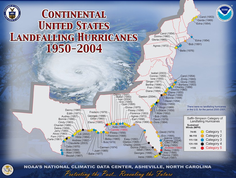
    Hurricane History

    NOAA has posted a timely site -- "Continental United States Landfalling Hurricanes 1950-2004" at http://www.nhc.noaa.gov/gifs/hur5005.jpg

    Deadly Arsenals: Weapons Maps Now Online

    The complete collection of maps from the Carnegie Endowments' "Deadly Arsenals: Nuclear, Biological, and Chemical Threats" is available at: http://www.carnegieendowment.org/static/npp/deadlymaps.cfm

    Wednesday, August 31, 2005

    GIS@Fenwick Workshops!

    The world's at your fingertips! Come and learn more about it at a GIS@Fenwick workshop. Staff provides:
    An overview of GIS, Hands-on Experience using ArcView and ArcGIS, and
    Libraries@ Mason GIS resources and data collection
    .
    It is open to the entire Mason community
  • Time: Every Wednesday 3:00-4:30 pm
    Every Friday 10:00-11:30 am
    September 7-November 11
  • Location: GIS Room, Government Documents, Fenwick Library.
    If you have any questions, please contact Joy Suh at hsuh1@gmu.edu (3-2238).
  • Wednesday, June 15, 2005

    New Database: Sanborn Maps (Digital Sanborn Maps)

    Access to Sanborn maps is now available through the Library Database wizard. The maps provide detailed information about street blocks, building materials, and utilities, etc. in cities and towns of the states of DE, DC, MD, and VA ranged from 1867 to 1970. They were originally created for the purpose of assessing risk of fire and cost of insurance. You can find the maps very useful for studies in the growth of cities and towns during the first half of the 20th Century.

    Wednesday, May 25, 2005

    MSN Virtual Earth

    Microsoft Inc announced a new product, MSN Virtual Earth, against Google Maps. It will be launched in this Summer. See the article at http://www.pcmag.com/article2/0,1759,1819155,00.asp

    Tuesday, May 24, 2005

    ArcIMS is Available!

    For those who want to produce web-based interactive mapping: you can do this in Fenwick Library. We have installed ArcIMS software on our GIS workstations. Please check it out in Fenwick Library, Government Documents/Map Unit.

    Monday, May 23, 2005

    Maps & Geographic Information Collections in Transition

    The recent two day conference on maps and geographic information in transition in D.C. was a hugh success. We all learned from each other by sharing information and experiences. Please take a look at Dr. Onsrud's licensing geographic data and services and Dr. Goodchild's future directions for Geolibraries. There were more sucessful stories of Harvard Geospatial Library and Inside Idaho projects. See abstracts of presentations at http://cuac.wustl.edu/AbstractsforPresentations.htm
    Power Point Presentations at http://www.cuac.wustl.edu/newPage.htm